Lofoten, if any, is a spectacular nature destination. It’s super scenic wherever you go, and the sea, sun and weather changes make it all look just magic.
Yet, for the best views of the islands you should get somewhere higher. But how? Just head to one of the many trails winding to mountain tops – most of which, however, are quite extreme.

One of the short Lofoten hikes to mountain tops: Heia, Henningsvaer
To climb vertical Lofoten mountains needs both skill, condition and a lot of time. We, instead, are just ordinary hikers and like the easier and shorter trails. Is there anything for us in the Lofoten Islands? Yes, definitely.
When planning our trip we searched for short but scenic Lofoten hikes and found some good ones.
Here they are, five short Lofoten hikes suitable for most travellers. They all take you to the heights, but with less effort. In only two or three hours there and back.
Easy, Moderate, Difficult
In Norway our five short hikes are mainly classified as Moderate – as most hikes are.
The scale is Easy, Moderate and Difficult, and it looks like the middle group contains a wide range of walks from pretty easy to extreme, and everything in between. So you should check before you go.
In any case, our five hikes are on the easier side. Here they are on the map:
Five Short Lofoten Hikes on the Map
Five Lofoten mountain top hikes on the map
This post will show you these hikes:
- Tjeldbergtind in Svolvaer,
- Heia in Henningsvaer,
- Hoven on Gimsøya,
- Mannen in Haukland and
- Reinebringen in the far south.
Zoom out the map to see the exact location and terrain of each hike, and feel free to use our Google itinerary to travel to them.

Lofoten in a campervan: choose your view for each night
We traveled Lofoten in a campervan which we think is the best way to explore rural regions and nature destinations. You can park where the trail starts and stay overnight in the most scenic places next to the hikes.
We will show you some of our favorite places to stay.
The hiking trip was the second time we went to Lofoten, read about the first trip here: Norway by Motorhome: Lofoten, Senja & Tromsø
Lofoten Hikes: How to Prepare?

Lofoten hiking: up and down rocky paths
How to prepare for a Lofoten hike? Some tips:
- Most important: good and steady hiking shoes. There will be loose stones and big rocks on the trail, and roots, sand, ground vegetation and mud.
- Clothing according to weather. At higher altitudes it will be windier and colder, maybe it will rain.
- Something to drink and eat. Taking yourself up a rocky path will wake up your hunger.
- A good hiking map and route description, sometimes there are no signs in the terrain. Check out our links after each hike and use the maps in them with your phone.
- And then: we needed gloves, cheap stretch gloves are good. In steep slopes you need to touch stones, sand, plants and trees. This way:


Chokolate on the summit!
So now the hikes. The first one was Tjeldbergtind (height 367 m):
Svolvaer: Tjeldbergtinden 367 m


Finally on the top! Great view to Svolvaer and Djevelporten
Svolvaer, the Lofoten capital, is the islands’ main tourist hub, and with a good reason. There is a range of activities on offer and fantastic trails. But most famous trails, Djevelporten, Floya and Blåtinden are straight up to almost 600 m!
Djevelporten looked so great but too extreme for us, at least to start with.
Tjeldbergtinden on the other side of the town is a bit lower, but the views much the same. Something for us!
Short Lofoten Hikes: Tjeldbergtinden


From forest to the ridge
Tjeldbergtinden has two tops and a long ridge in between. It’s a 3,8 km loop walk (2 hours) and maps tell which direction you should go.
First you will follow a forest road towards the tele tower on the hill, until just before it there’s a path uphill.
It’s a an easy forest path but will soon get quite steep. Surprisingly steep! To get uphill we had to use our hands at whiles, and even more so on the way down the other path.
Then, on the way down we noticed we can use tree branches as lianas, hang in them and skip from rock to rock. That was real fun, just can’t believe we came down that way!
After all, we liked the Tjeldbergtinden hike a lot. Though on the way up the steep slope I thought coming down will be a nightmare. It was not and before we noticed we were back by the road.
The ridge on the top is treeless and narrow and offers a stunning Lofoten panorama. A perfect picnic spot after all the sweating on the way up.
As the highest top needs a super steep extra climb we skipped it. Many other walkers climbed that as well, but we had seen the views and took the path down:


Tjeldbergtinden, we made it!
A splendid hike and fantastic views into all four directions: Svolvaer and the mountains beyond it, the Arctic Sea and the Kabelvåg coastline on the other side. And those dark inland lakes on the north side!
Tjeldbergtind Hiking Map and Route Description
For information on the hikes we mainly used the Outdooractive website. Check out the route details and hiking map here (or download their Outt app):
The hike begins behind the Osan Esso south of Svolvaer. Uphill from the gas station is a small car park and a bigger one exists at the supermarket where you can buy your picnic and fill the fridge at the same time.
Where we stayed overnight:


Sandvika Camping, Kabelvåg
In the nearby Kabelvåg we found a stunning camping where you can park right by the sea or higher up between cliffs. And next door exists another camping that looks equally nice. See more: Sandvika Fjord- och sjöhuscamping.
Then in the morning, from Kabelvåg it’s just a half-hour drive to the Henningsvaer road where the next hike starts:
Henningsvaer: Heia 209 m

Summiting the Heia mountain above Henningsvaer
The Heia trailhead is on the Henningsvaer road just before the last big bridges. The location is the road bend after Fjordgård harbor.
In fact there are two hikes starting in the same place. The other hike is to Festvågtinden, 541 m. In addition there’s a climbing wall.
So of the three Heia is the easiest: only 1,4 km and 2 hours.
The hikes use the same trail uphill, a really rocky one and almost vertical at the end. The trail begins with huge rocks, between which you are supposed to find your way. Afterwards the rocks get smaller and higher up there’s a forest.
After the steep climb the two trails separate to opposite directions. From here on, Festvågtinden needs a heavy climb.
The rest of the Heia hike, instead, is an easy forest path on which the stunning mountain lake Heiavatnet is an extra bonus.
After all, Mount Heia (altitude 209 m) is not hard to reach at all but offers gorgeous views down to Henningsvaer, its many small islands – and the whole region!
Lofoten Hikes, Heia in Photos:


Hey from Heia, Lofoten!
A short but steep, stony hike where we had to use our hands both on the way up and down. Despite all, definitely worth the effort!
Heia Hiking Map and Route Description
Route details and hiking map on the Outdooractive website:
Where to park: we parked in the tiny Fjordgård harbor and paid with an app we had to download for that purpose. From the car park it was only a few hundred meters to walk to the trailhead (hidden behind trees, no sign).
As the end of August is low season already we had no trouble with parking, yet during the main travel peak it’s a different story. The road is absolutely too narrow to park and extensions are few.
However, there’s a big parking area further on, just before the last two Henningsvaer bridges:


Campervanning on the stunning Lofoten islands: Henningsvaer
For us, the big parking area was the perfect place to stay the night. It was a fantastic, sunny evening and the cliffs here face west and get the evening sun better than anywhere in the village. Even when it was on the road side, there was no traffic and only four or five other campers were present that night.
Then, you must to go and look at Henningsvaer. Or read about the village in the post Norway by Motorhome: Lofoten, Senja, Tromsø. The same post will also show you how great the north of Lofoten looks like.
Then the next hike, it was Hoven:
Gimsøya: Hoven 358 m

Fjord and island view from the top of Hoven
After two steep climbs we wanted an easier day and went to the gentler, pyramid-shaped Hoven on the next island Gimsøya.
Hoven an isolate mountain surrounded by lowland so no other mountains exist nearby. Until now our hikes had been moderate but this one was listed as easy. Let’s see…
We left the van at a horse farm, Hov Gård. That’s where the trail starts. the other option is by the golf course almost next door.
Hoven, the Hike
Yes, it was an easy hike, only 3,7 km and three hours, first through green, wet meadows and pasture landscape after which the climb started. Like elsewhere there were loose stones, roots and mud, but also small trees and bushes to help you uphill. But it was not hard at all, Hoven clearly is an easy trail.


Hiking Hoven, Gimsøya
Seen at a distance Hoven almost looks like stairs. Steep sections alternate with easier stretches where you can just walk.
So nice just to walk, and in a super soft terrain like this! Just walk and not fight the way up on all fours (which of course is great fun as well)!
The hike follows the long ridge to the top and back the same.


Hoven is one of the easier Lofoten hikes
Then, after the last steep section we reached the top at 358 m, and the views again, they were just as breathtaking as elsewhere! The whole Lofoten is breathtaking!
And here, on this fell we found the first red ground colors. The Arctic summer was already turning towards autumn.


Hiking in Lofoten: Hoven
Looking for an easy hike with mountaintop views? In that case Hoven might be for you.
Hoven Hiking Map and Route Description
You will find Hoven route details and hiking map here:
Back from the hike we saw we had parked in a place where we could stay overnight. We really liked the horse farm and ended up staying two nights. The next day was a working day and there were Teams meetings so we spent the whole day in the van. No hiking that day!
Just like the Henningsvaer cliffs, Hov Gård gets the evening sun. So we spent the evenings walking on the ocean shore – together with horses!


Hov Gård: camping on a horse farm
Read more about Hov Gård, Lofoten
Then, the next day was a driving day. We headed on to Leknes that turned out to be too urban. We only stopped at a supermarket and continued. Whereto next?
To the north part of the island where a real gem exists:
Haukland Beach: Mannen 400 m, Uttakleiv Loop 8 km


Lofoten hikes: Haukland sheep
Haukland is such a lovely place that once we had arrived, we just couldn’t leave. The days we hiked and the evenings sat by the campfire staring at the sea.
We found a tiny private camping field right on the beach and each evening the owner came for the payment. Just perfect!
That was in Vik, the next village. And needless to say, this place, too, got the evening sun!


Enjoying the Lofoten evening sunlight
Otherwise, parking in Haukland is a big problem. The local cafe has a parking area but it’s far too small for all that want to visit. An option is to take the tunnel to Uttakleiv and park there.
Haukland Hikes

Rock climbing to Mannen, 400 m
So what about the hikes?
In Haukland you can hike round the peninsula to Uttakleiv, and walk back the same, or return over the mountain ridge. That makes a nice 8 km loop walk. The ascent to the ridge is no more than 200 m along a good path, not rocky like in the photo above. That’s from Mannen.
The walk around the peninsula uses an old post road from 1947, almost drivable but closed for traffic. Instead there are grazing sheep – and splendid sea views all way round.
The mountain path again dates back to 1850, it’s where children from Uttakleiv used to walk to school to Haukland. To make the school road easier they built the flat peninsula road and after some more decades a tunnel road.
Then, from the ridge between the two villages you can get higher, to a fell called Mannen, 400 m. Mannen is located on the peninsula and further away fell Himmeltinden, 931 m, a hiking destination as well.
Lofoten Hikes: Mannen and Round the Peninsula
Our longest hike went 400 m up to Mannen, down to Uttakleiv and back round the peninsula, so to make it longer we combined two hikes. It was about 10 km and took about half of the day. I will show you that hike in photos:


Lofoten hikes: Mannen and Uttakleiv from Haukland Beach
So Haukland has many places to hike to and you can easily spend there two or more days. And more hikes exist at a short driving distance. The Haukland scenery is unbelievable and there are trails to suit all skills.
Haukland Hiking Maps and Route Descriptions
Check out Haukland routes and hiking maps:
Read about the middle islands of Lofoten in this post: Norway by Motorhome: Lofoten, Senja & Tromsø
Then, last but not least, Reinebringen, the most popular hike of Lofoten:
Reine: Reinebringen 448 m

Lofoten hikes: view to Reine from Reinebringen
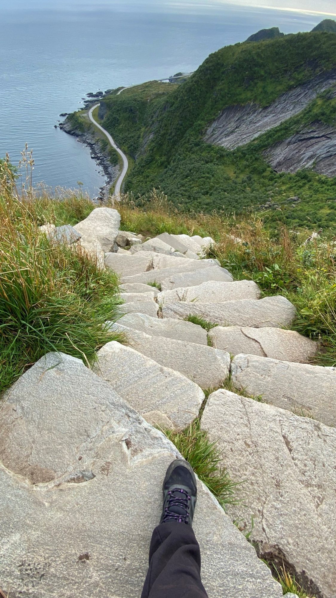
Located in the remote south Reinebringen is a short 2 hour hike, but not an easy one. It’s incredibly steep.
Reinebringen is an out and back trail of only 1 km one way and used to be one of the most dangerous climbs in all Norway. First it was so steep and secondly there was rockfall and erosion that caused a lot of accidents during years.
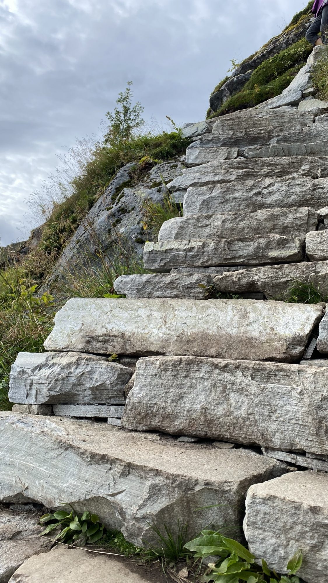
Sherpa Steps to the Top
Then, in 2016 they hired a Nepali Sherpa team to build stairs into the steep mountainside. After three years the stairs were there, built of natural stone blocks, each of them different. The Sherpas had built stairs almost all the way to the top!
Only 50 m of steep, muddy path remains on the mountain top but right now there’s no funding for the project. The remaining 50 m is dangerous particularly in wet weather and there’s a risk for rockfall, but luckily there are the 1566 steps!
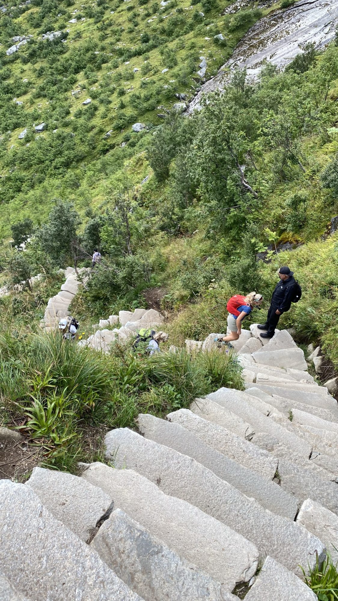
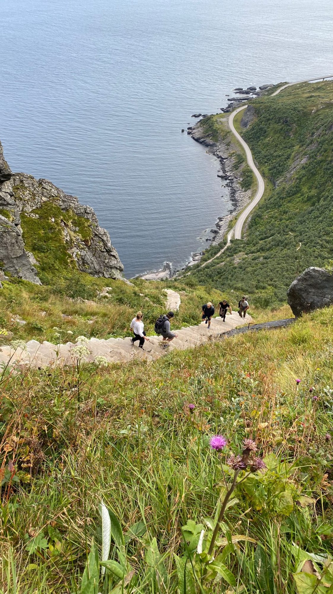
Yes, they are currently 1566 in number and each step is high like on the China Wall. To take the stairs up is physically demanding and you will have to rest at whiles. For that purpose there are extensions with benches.
Hard to believe, but the hike is mentally demanding as well. It’s so steep and there’s no handrail or anything else to get a grip from.
At least coming down can be a mental challenge with the steep, spiral staircase opening up below you:
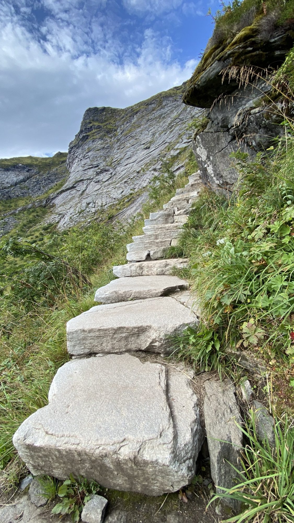
Lofoten hikes: Reinebringen Sherpa steps
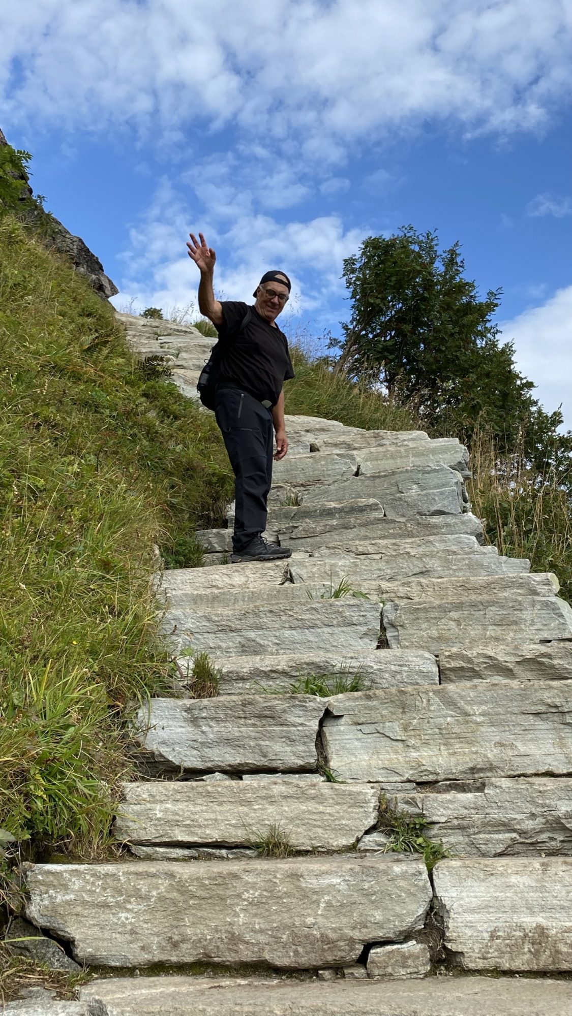
Yet challenges are meant to be overcome and so were the Sherpa steps. Up we went, and came back down!
Tremendously Popular Hike
After the stairs were completed all Norwegian and international tourists wanted to visit.
In July you can see hundreds of visitors taking the stairs up and back down, each day of the season. However, the season is just a short time and already after mid August there were no crowds at all.
If it’s peak season, try to arrive when others don’t, in the early morning or late evening. Nordic summer days are long and nights white and maybe a good hiking time?
The stairs take you up to 400 m, the place for the iconic view, and from there you can walk on to the highest top at 623 m if you like.
Most climbers, however, are happy with the famous view and take the stone blocks back down:


We made the long Reinebringen stairs up and got the view!
Hiking Map and Route Description
Route details and hiking map:
This is the trailhead south of Reine, at the south end of Ramsvik tunnel:

Five short Lofoten hikes: Reinebringen trailhead
The trailhead is a 1 to 2 km walk from Reine, depending on where in the village you start from. Just follow the old tunnel road on the seaside of the tunnel.

View of Reine, Lofoten
There’s a car park at the Reine road crossing, probably full, and a huge one in the outer harbor beyond the village, and a third one in the village.
We parked in the harbor where we stayed the night as well. I wouldn’t call the harbor pretty, but the views! And the village itself. With the scenery it was a really good place to park for a night:


Campervanning in Reine Outer Harbor
Once you have seen the south part of Lofoten you will understand why it draws tourists like a magnet. Everything in the south looks so pretty, so this is one more place from where you just can’t leave. Å, Sørvågen, Reine, Hamnøya and all others…
Read about the south of Lofoten: Norway by Motorhome: Lofoten, Senja & Tromsø
Prolong your stay here if you can. That’s what we did.


Å, Sørvågen and Hamnøya in the South of Lofoten
So that was it, our five short Lofoten hikes, all of them great experiences. What about you, what are your favorite hikes in the islands?
Absolutely brilliant! Thanks. I was there in 2019 and I’m returning this year. Wonderful blog.
Thank you Liisa, this was absolutely brilliant. It came up on my Google feed and hesitated to click on it since I thought it would contain lots of ads. Couldn’t have been more wrong!
We are on a long road trip in our camper van and your superb guide was a big help. I will be using your guides regularly. Keep up the good work, it is much appreciated
Hi Martin and thanks for the kind words :). A long road trip in a campervan sounds fantastic. Have a good time!